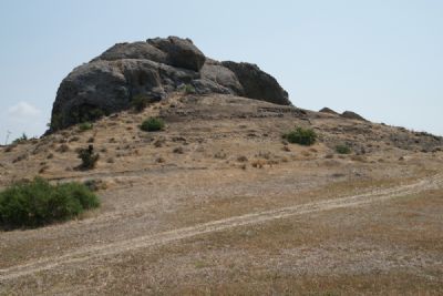
Kataliondas-Kourvellos, the rock knob
Identifying Slag at Kataliondas-Kourvellos, using hyperspectral imaging (2015)
The application is related to a short-term, non-invasive field research project, relative to the identification of traces of ancient copper slag in the wider area of Kataliondas-Kourvellos, in the lower Troodos foothills, as well as to the acquisition of the spectral signature of ancient slag. The project is under the direction of Dr. Julien Beck (director of the Swiss Kataliondas-Kourvellos excavation, University of Geneva) in collaboration to Cyprus University of Technology (CUT) and Prof. Bertrand Merminod from the École Polytechnique Fédérale de Lausanne (EPFL).
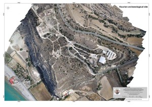
Kourion orthophoto
Kourion Urban Space Project (KUSP) / 2014
The ARCH team as consortium partner of the KUSP (directed by Dr. Thomas W. Davis of the Tandy Institute for Archaeology at Southwestern Baptist Theological Seminary in Fort Worth Texas, USA) completed a UAV low altitude flight above the archaeological site of the acropolis of ancient Kourion in Limassol District. The result of the flight was an orthophoto of high resolution, in combination with other identification techniques will permit planning and orientation for the forthcoming excavation seasons. Read more in PIX4D website
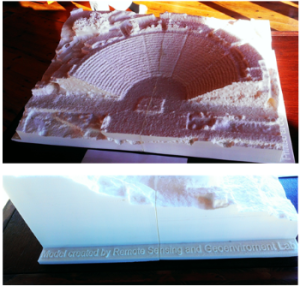
3D printed sample of Kourion ancient Theater
In addition to that, a 3D model of the ancient theater was printed by “CUTing Edge” of Cyprus University of Technology. The model is now exposed to the local Museum of Kourion, serving for educational reasons, being at the same time extremely useful for visually impaired people.
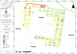
Managing Cultural Heritage Sites through Space and ground Technologies using Geographical Information Systems: A Pilot application at the archaeological sites of Paphos (RiskA) / 2012-2014
The general objective of the project included the development of a new methodology and framework for monitoring Cultural Heritage Sites and Monuments of a wider area. Integrating to the traditional site observation practice, in which the coverage is limited, the methodology developed for the needs of the present project, put together both satellite and ground innovative technologies (such as satellite images, LIDAR sensor, GIS, sun-photometers etc), in an effort of a more complete and distant monitoring and management tool. Indeed, the project’s outcome can be described as a ‘forecasting tool’ for the protection and management of CH, endangered from anthropogenic and natural hazards. Such methodology can be integrated into the stakeholders decision-making process, so that preventative measures could be taken to reduce risks related to monuments. Furthermore, the proposal promotes sustainable development and protects CH using utterly non destructive methods.
The research project was submitted and funded under the Framework Programme for Research, Technological Development and Innovation of the Research Promotion foundation and lasted for 2 years.
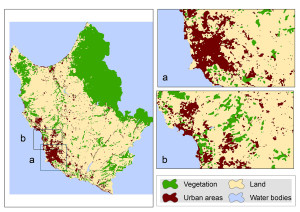
Map indicating urban sprawl in the District, relative to the Monuments/Archaeological Sites
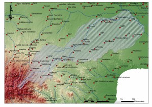
Mapping the ancient cemeteries of Tilliria region, Cyprus / 2008-2013
ARCH team accomplished the mapping of the ancient cemeteries of Tilliria region. The project involved by the researches of the Lab, both archival and in situ survey. The collected data were introduced into a GIS environment for further analysis regarding the archaeo-landscape of Tilliria area. The project was conducted in collaboration with Kykkos Museum and the Department of Antiquities of Cyprus.
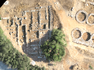
Documenting archaeological excavation of Avli, Pano Pyrgos Tillirias / 2008-on going
The archaeological excavation at the site Avli in the village of Pano Pyrgos Tillirias, a collaboration beween the Department of Antiquities of Cyprus and Kykkos Museum, started on 2008 and is still going on following the sporadic excavation seasons. The ARCH section of the Lab was involved from the beginning of the project, for the documentation and GIS analysis of the site.
General view of the ancient necropolis
Sotira ancient necropolis Ammochostos / 2014-on going
The ARCH team in collaboration with the Department of Antiquities of Cyprus, was involved in the safeguard of the ancient cemetery in Sotira village, at the locality Mnimata ton Ellinon. During the first phase of the project the mapping of the ancient cemetery, as well as the individual tombs was accomplished. The second phase of the project, still on going, regards the architectural documentation of the excavated dromoi that lead to the tombs, as well as some of the visible facades of the tombs.
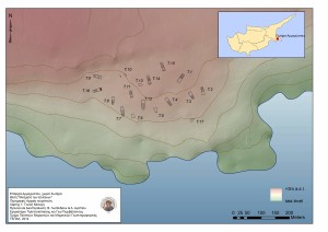
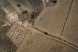
Ayios Sozomenos project, study area of the archaeolandscape mapping
Ayios Sozomenos archaeological project / 2014-on going
An important archaeological excavation was initiated by the Department of Antiquities in 2012 (Director: Dr. D. Pilides) in the area of Ayios Sozomenos village. The ARCH team contribution is the development of the GIS of a wider area around Ayios Sozomenos excavations, in order to document the archaeological visibility of the area and to make the appropriate analysis in a landscape level.
Aerial photographs of Colossi castle, Limassol
Development of a low altitude airborne remote sensing system for supporting the processing of satellite remotely sensed data (ICAROS) / 2011-2012
In the ICAROS project several technologies have been merged in order to create an innovative low altitude airborne system supporting remote sensing and photogrammetric applications. Amongst the various application case studies of the project was the use of copter to document archaeological sites in Cyprus.
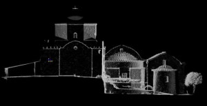
Point cloud of Ayios Hrakleidios complex
Documentation of the Holy Monastery of Ayios Hrakleidios, Politiko / 2014 – on going
In collaboration with the church committee the ARCH section accomplished the detail documentation of the monastery including both the church and the underground tomb of saint Hrakleidios. Both laser scanner and photogrammetric techniques were applied.
Palaepaphos Urban Plan / 2014-on going
UAV flights over Palaepaphos landscape (Coordinator: Prof. M. Iacovou) were applied in an effort of updating the existing topographical information. Further more, the documentation and 3D model at the end of each excavation season are being progressed.
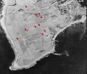
Spots identified through remote sensing techniques
Unburied antiquities of Nea Paphos / 2012-on going
Systematic observation both satellite and terrestrial of specific areas in Paphos town have been effectuated within the last years. The target is the detection and mapping of still unexcavated or reburied archaeological remains. As an outcome of the project a dramatic reduction of the visibility regarding buried remains was observed within the last 30 years, mainly due to change of land use.
Malia Palace, Crete / 2012
A collaboration between FORTH, EFA and CUT led to the 3 dimensional documentation of the palatial complex at Malia site in Crete, Greece. The site had urgently to be documented in order to be reburied for protection. The laser scanning of the site led to an extremely detailed documentation of each architectural element and its components.