
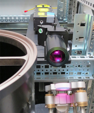
Lidar Station
The Remote Sensing Lab is equipped with a wavelenght Raman LIDAR, which performs continuous measurements of the atmospheric aerosols in the Planetary Boundary Layer (PBL) and the lower troposphere. The LIDAR system is located at the Remote Sensing Lab and has been part of the EARLINET program since September 2011. The LIDAR system meets the quality assurance test according to EARLINET protocol.
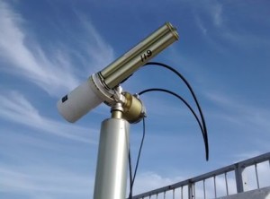
AERONET Station / CIMEL Sun-photometer
The CIMEL sun-sky radiometer is part of the AERONET Global Network (http:// aeronet.gsfc.nasa.gov). The CIMEL is an automatic Sun-sky scanning fiter radiometer allowing the measurements of the direct solar irradiance and sky radiance at wavelengths; 340, 380, 440, 500, 670, 870, 1020 and 1640 nm. The CUT_TEPAK AERONET station is located in the old town of Limassol, 500 m from the sea. The CIMEL sun-photometer has been in operation at the Remote Sensing Lab since April, 2010.
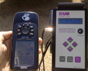
Microtops Sun-photometers
The Remote Sensing Lab is equipped with two Microtops II hand-held sunphotometers, which measure the attenuation of the direct solar irradiance and the aerosol optical thickness (AOT) of the atmosphere in the fild.
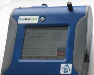
TSI DustTrak
The TSI DustTrak is a light scattering laser photometer that is used to measure PM10, PM2.5 and PM1 concentrations. Such measurements are useful in identifying air quality values.
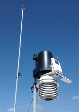
Meteorological Stations
Various meteorological stations, located in different parts of Limassol, are owned by the Remote Sensing Lab. These instruments are equipped with rain collectors, temperature and humidity sensors, anemometers, solar radiations sensors and UV sensors which measure wind, temperature, apparent temperatures, wind chill, heat index, temperature/humidity/sun/wind (THSW) index, humidity and dew point.
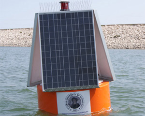
Smart Buoy System
The Smart Buoy System, an innovative and energyautonomous floating sensor platform that has the ability, through a wireless network, to transfer data to a remote central database. It is equipped with various water quality sensors for real time monitoring of water quality and measures water turbidity, water temperature, humidity and air temperature.
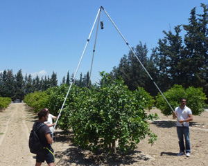
Field Spectroscopy Lab
The Lab is equipped with 5 field spectroradiometers (GER1500, SVC HR-1024, ASD hand-held 2) with coverage from 350nm up to 2500 nm, white spectralon panels, fire optic probes & diffuser, underwater enclosure for GER 1500 spectroradiometer, open sky integrating cosine receptor sphere, leaf reflctance probe system, integrating calibration sphere, HgAR & Krypton spectral calibration lamps, software for processing spectroradiometric data. All the equipment is suitable to collect ground truth spectroradiometric data over different targets such as rocks, soils, water bodies and vegetation. The Lab is capable of performing instrument calibration and testing. Applications include environmental monitoring and assessment, agriculture, water quality, geology, forestry, industrial, defense and intelligence, etc. Meteorological Stations Various meteorological stations, located in different.
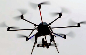
Unmanned Aerial Vehicles (UAVs)
The Remote Sensing Lab, in cooperation with the Cyprus Remote Sensing Society, is equipped with various UAV systems for remote sensing applications. The UAV systems include long range flght coverage with the QuestUAV glider and short range flght coverage with various drone systems. The drone systems have the capability to lift heavy payloads, such as spectroradiometers and other sensors. Also, a low altitude helium balloon is used for various applications. The Lab’s UAV flet includes the following:
- Heavy-lift Octokopter UAV system capable for lifting SLR cameras and spectroradiometers
- Hexacopter UAV system for spectroscopy, multispectral and thermal imagery acquisition
- Quadcopter UAV systems for aerial photography, photogrammetry and spectroscopy
- Aerial survey QuestUAV with long range system capabilities equipped with multiple camera sensors for NDVI and high resolution imaging. The UAV is capable of producing highly precise, survey grade 2D orthomosaics, 3D surface models and point clouds. The unit has a twin NDVI sensor, which is suitable for high resolution analysis of vegetation and crop health as well as high quality ortho and DEM generation. The UAV is flxible in launching and also features a parachute recovery system for landing. It is fully autonomous, as it provides auto-launch, waypoint navigation, task/payload management and auto-recovery
- A 3 meter diameter low altitude helium balloon remote sensing system with spectroradiometer and multispectral camera. The UAV systems can be used for a wide range of remote sensing applications, including agriculture, land survey with up to 2 cm resolution, archaeology, cultural heritage, cadastral surveys, high altitude surveys, forestry, land management, aerial photography, photogrammetry, surveillance, etc.
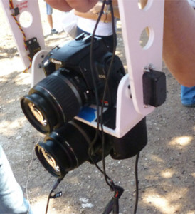
Camera Systems
The Remote Sensing Lab is equipped with several high resolution and specialized cameras, which include the following:
- NDVI Camera: Canon ENDVI (MaxMax) is able to capture Enhanced Normalized Difference Vegetation Index (ENDVI), d e s i g n e d for Vegetation Stress (12.1 megapixels at 4000 x 3000 pixels)
- Multi-Spectral Camera: Multi-spectral Agricultural Digital Camera (ADC) for multispectral imaging of crop canopies and vegetation for extraction of standard vegetation indices (such as NDVI, SAVI, canopy segmentation and NIR/Green ratios) from the captured images
- Infrared cameras: Modified infrared cameras with blocking fiters of 650nm, 720nm and 760nm
- Thermal camera: The Optris PI LightWeight thermal camera system allows for radiometric imaging with 382 x 288 pixels in 12 ms per frame from the air

Ground Penetrating Radar (GPR)
Ground penetrating radar systems can detect changes in the geometry of subsurface interfaces, which is useful in surveying below ground. The MALA ProEx System offers a versatile, real-time full range ground penetrating radar system with ground penetration up to 10 meters. Applications include archaeology, cultural heritage, utility lines and other buried objects.
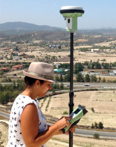
GPS
The RS Lab is equipped with various stateof-the-art GPS systems that are able to receive both GPS and GLONASS signals and are used for surveying, mapping and stakeouts. With this technology, accurate signal tracking can be performed and RTK measurements can be verifid to ensure reliable results with high accuracy.
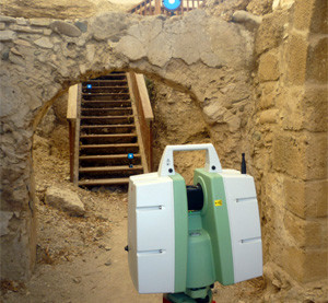
Laser Scanner
The Leica ScanStation C10 laser scanner may scan up to 50,000 points per second, while the accuracy up to ±6mm/50m distance. The field of view of the Scan Station is 360o x 270o. The instrument may be used for documentation purposes of Cultural Heritage sites and monuments as well for documentation of buildings and structures.